Not an oddity, perhaps, global coastlines everywhere are subject to constant erosion from the sea, but more intensely in recent decades.
In Bay of Islands, the receding waterfront is plainly evident — and precarious.
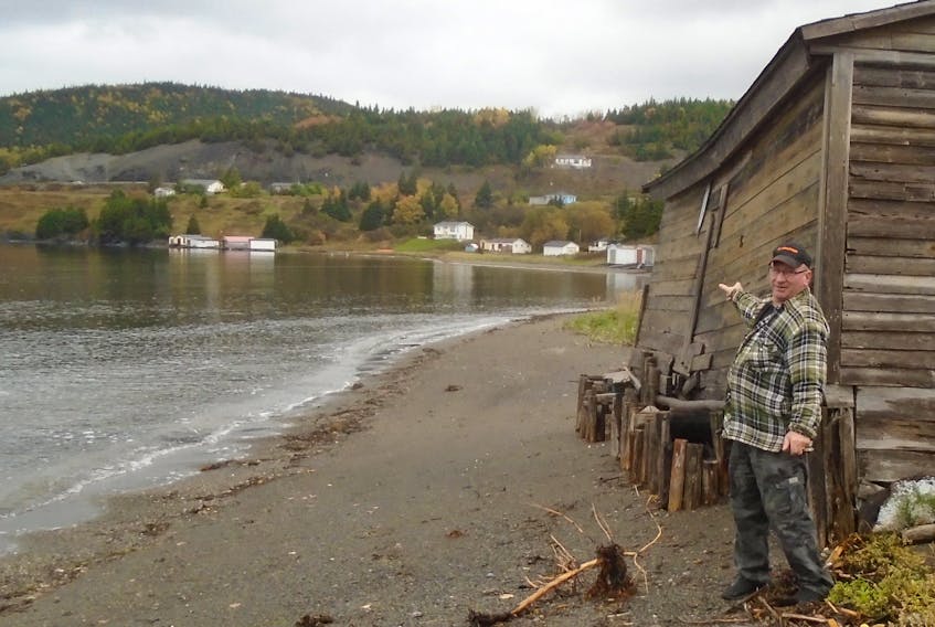
Basil Park is 56, old enough to have a young memory of what the land was was like when he was growing up.
“There is something going on,” said Park, standing on the edge of a grassy garden from his youth that has since been transformed into a pebbled sandy beach.
Not that the kilometre-long beachhead that is McIvers Cove wasn’t always there, but it now offers a wider and steeper landing than it did when his grandfather Augustus settled the spot more than 100 years ago.
The beachfront is witnessed to have moved metres further inland during more than a half-century since the young Mr. Park has observed its migration.
The advance of the sea is unrelenting on the old Park family homestead, as it is elsewhere in McIvers.
Lacking any functional breakwater, another bit of its green edge was chewed away again in a storm surge last weekend.
Explanations — however tenuous or tawdry — doesn't change the fact that proximal waterfront properties are under seige.
“I says it could be (partly the result of oceanic mining for fossil fuels) when they take out the oil by pumping water in (for extraction from the subsea basins) and because it is heavier than oil, they are changing everything underneath the water,” Park commented.
Certainly, scientists define to a fossil fuel connection said to be evoking extreme atmospheric weather, promoting accelerated glacial melt, causing rising global sea levels and the increased coastal erosion that comes with it.
Indeed, the evolving saltwater egresses on the north shore of Humber Arm in the old fish-farming hamlet exhibits prime examples of a shoreline under attack.
Still, as the tides make higher, winds blow stronger and larger waves cash farther ashore, it is not without cause Park has purposely moved his family potato patch further up in the field.
Park does not entertain thoughts that the family home is seen to sit perched on an embankment not far above the beach’s highwater mark; though it is clear that the footings of an old family fishing stage and storage shed just below have been mostly reclaimed by the tide so far.
A storm surge about four years ago washed out the foundation of an older woodshed there, the latest among a series of reclamations that earlier included the loss of a fishing skid, as well as an old chicken coop further removed from the shore.
Park allows that the changing waterfront in his area may also be contributing to the shifting of hilly backwater land previously used for farming, and one day, he said “it could all slide out in the bay.”
Further down the long beach, on the other side of McIvers Brook inside Larkin's Point, other private fishing sheds sit precariously on piles that allow the sea to sweep harmlessly underneath, but the sandy access road to that area is under pressure of being washed out.
On Blanchard’s Cove, older fishing facilities are foundering on an unkempt wooden seawall long hammered by violent wind, breaking waves and pummelling winter ice swept along in the annual onrushes of the untamed North Atlantic Ocean.
“Oil … is making a mess of the world,” Park says.
“The world is changed big time.”