Some other schools in the eastern region are closed all day, while others will update mid-morning.
Updated list of schools' status can be found here.
For the College of the North Atlantic, the Prince Philip Drive (including the day care centre) and Ridge Road campuses will remain open with an update at 3 p.m.
Seal Cove campus is open.
Burin campus, Carbonear and Placentia campuses are closed.
Eastern Health's parent information session entitled Anxiety in Children: What it Looks Like and What You Can Do to Help, scheduled to take place this evening from 6 -8 p.m. at the English School Board District Conference Centre, 40 Strawberry Marsh Rd. in St. John’s, has been postponed due to the weather.
This session will be rescheduled at a later date. Parents who have registered for this season will be contacted to be registered for the new date.
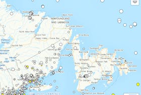
Snow and rain are still over the next couple of days are expected on the Avalon Peninsula, Environment Canada says.
Snow is forecast to begin across the Avalon this morning, and will change to ice pellets and freezing rain, and then to rain during the evening as temperatures rise. Snowfall accumulations are expected to range from 10-15 cm.
Rain is then forecast to continue through the day Tuesday, at times heavy. Some 10-20 mm of rain are possible by Tuesday evening with additional amounts likely on Tuesday night.
Among the other weather watches, Clarenville and vicinity expects 15-25 cm of snow by this evening.
Snow over the south coast of Newfoundland will spread northeastward this morning and continue through the day.
Gander and Bonavista North: Snow is forecast to begin this morning with accumulations of 10-15 cm possible before the snow tapers off late this evening. A period of freezing rain is expected to begin Tuesday morning before changing to rain as temperatures rise.
Grand Falls-Windsor to Bay of Exploits and west: Snowfall accumulations of 2-5 cm can be expected today. A significant period of freezing rain is possible Tuesday and freezing rain warnings may be required.
Many areas will experience a period of freezing rain or ice pellets before changing over to rain this evening.
There are no weather watches for much of the west coast, the Northern Peninsula or Labrador.