Well, you certainly can’t say that the weather in Atlantic Canada is boring.

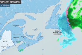
Wednesday, May. 23, we experienced rain, snow, hail, a thunderstorm and violent wind gusts. Depending on where you were at the time, you may or may not have experienced any or all of these. There was a lot of talk about the snow, and rightfully so; we don’t often get 5 cm of snow in Bathurst, N.B., and 33 cm in Gander, N.L., so late in the month of May. Jaw-dropping photos generated a lot of talk on social media on Wednesday and Thursday, but the wind was not mentioned very much; it was, however, significant and a little unusual.
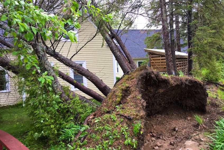
After the storm had passed, Samantha submitted a photo of downed trees on her parents’ property in Fredericton, N.B. I checked with hourly weather reports and they didn’t seem to support the kind of damage you see in the photo: winds were clocked at 30 km/h with gusts to 45 km/h. It took more wind than that to snap those trees. I went back and had a closer look at the radar charts at the time of the damage. The line of thunderstorms was intense. The warm air ahead of the front was being driven upward by much colder air behind the system.
All indications point to a “gust front.” While fairly rare around here, gust fronts are like miniature windstorms that can be a side-effect of a strong thunderstorm nearby. They can also be a sign you're about to get quite wet. During a very heavy rainstorm, the downward force of the falling rain creates a cool, strong, sinking wind. As this rush of air reaches the ground, it races outward ahead of the storm. Some of the strongest storms can create gust fronts with wind speeds of more than 150 km/h.
Gust fronts can also spawn a secondary storm near the original thunderstorm. As the cold air rushes outward, it can force the warm air on the ground to rise up and condense, creating a new thunderstorm. If you’re standing ahead of a storm and you feel a blast of cool air, that’s the gust front!
The gust front travels quickly and changes appearance very quickly. Another good reason to keep an eye on the sky!
Thanks for the photo, Samantha!
- Want more weather information? Visit WeatherByDay.ca
- Have a weather question, photo or drawing to share with Cindy Day? Email [email protected]
Cindy Day is the chief meteorologist for SaltWire Network.