Rugged and remote, steeped in culture, history and mystery, Isle Haute lies near the entrance to the Minas Basin in the Bay of Fundy. It is visible from hundreds of kilometres of shoreline in Nova Scotia and New Brunswick when not hidden by its ubiquitous fog.
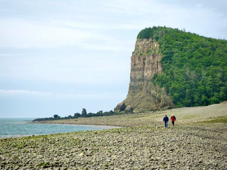
The island was named by explorer Samuel de Champlain when he visited there in 1604. He named it Isle Haute (French for High Island) because of its soaring 100 metre high volcanic basalt cliffs, which date back to the Jurassic period (199.6 to 145.5 million years ago).
Isle Haute sits nine and one-half kilometres west of Cape Chignecto Provincial Park in Cumberland County and 18 kilometres from Harbourville in the Annapolis Valley. It is about 2.5 km long and a half kilometre wide and is technically part of Cumberland County.
Depending on the weather, which is volatile in the midst of the highest tides in the world, Isle Haute’s appearance from the mainland or even by boat can seem to change from one day to the next. Fog can create an impression the island is floating and Mi’kmaq folklore talks of Isle Haute moving, liable to disappear and reappear in various places in the bay. The Mi’kmaq name for the island is Maskusetkik, which means place of wild potatoes.
Cumberland-Colchester MP Bill Casey has long been an ardent fan and supporter of everything Isle Haute has to offer. He and his brother first visited the island as teenagers and Casey has returned almost every year since.
Casey says he is not surprised when he learns that some Maritimers have not heard of Isle Haute as it doesn’t always appear on every map of the area. The island was declared surplus by the Department of Fisheries and Oceans in the 1990s and Casey’s love for the island turned into urgent protectionism when he saw an article in Canadian Geographic Magazine in 2001 advertising that the island was for sale.
Casey has worked diligently for 16 years and with four federal governments to ensure Isle Haute stays out of private hands and that its beauty, history and integrity be preserved.
Although Isle Haute is currently uninhabited (it is owned by the Canadian government) it was at one time a busy hub of trade and activity. At a time when trade was primarily conducted by boat, the island became a stopping point for many ships and barges.
Isle Haute was also home to upwards of 20 shipwrecks, most of those wooden sloops, the first recorded in 1786. Vessels were often caught off guard by a treacherous gravel bar — Quaco Ledge — on the island’s west side that lies just below the surface at high tide.
Booming trade and the need for safety eventually led to the building of a lighthouse at the highest point on Isle Haute in 1878. The 53-foot lighthouse was a virtual twin to one still standing on Wood Island, P.E.I.
- CINDY DAY: Early morning blues over the bay
- MP Bill Casey: Isle Haute should be national wildlife area
- Throwback Thursday: Keeper of Isle O’Haute lighthouse
The island was home to five different lighthouse keepers and their families who cleared and cultivated the land atop the island. During those years, they exported substantial numbers of cattle, sheep and hay to the mainland. This all came to an abrupt end in 1956 when the lighthouse, dwelling house and adjacent barn burned to the ground.
The original lighthouse was replaced by an automated beacon and the only other permanent structure on the island now is a wood helipad near the new light, which is serviced by the Canadian Coast Guard.
Isle Haute is known to have been a Mi’kmaq campground for centuries and many Acadians also fled to Isle Haute in 1856 to escape the British invasion on the Nova Scotia mainland. Historical reports also say that at the turn of the century, as many as 300 people per day would arrive on Isle Haute from the mainland for popular picnics and bay parties.

Home of treasure?
Isle Haute is rich in pirate lore as well. In July 1952, U.S.-based Life magazine ran an article by American pirate author Edward Snow about possible buried treasure there. It was supposedly taken from the Spanish galleon Señora de Victoria by notorious pirate Captain Ned Low. Low was rumoured to have buried his treasure on Isle Haute while fleeing a raid in New England in 1722. Low was eventually captured, however, and hanged in the U.S. without disclosing the exact location of the bounty.
In 1947, Snow came into possession of a map confirmed to have been drawn on 17th Century paper and reputedly drawn by Low. Snow eventually determined it to be a map of Isle Haute, believing it showed the site where Low’s treasure was buried. Snow was then funded by U.S. investors to search on Isle Haute for the treasure.
When Snow arrived at Isle Haute he stayed at the lighthouse with keeper John Melvin Fullerton.
Soon after his arrival, Snow picked up a reading with his metal detector at a previously dug pit on Isle Haute’s rocky beach. He returned with Fullerton to complete the dig the following day and found what he alleged were several Spanish and Portuguese coins, estimated to be at least 200 years old.
Snow published his story and photos in Life magazine but his find has always been questioned as to whether it was authentic or a plant on his part. There remains no actual evidence that Low or any other pirates buried treasure on Isle Haute.
Unfortunately, the area most favoured by Snow and other treasure hunters is also one of its most significant archeological sites on Isle Haute. It lies at one end of a salt pond and years of digging has left two large five-metre crater-like depressions and numerous other holes that pock mark the rocky beaches.
Because the island is isolated and uninhabited it is also difficult to monitor. It is currently against the law to dig on Isle Haute under the Special Places Protection Act which protects “any land, including that which is covered with water, with significant archeological, historical or palaeontological importance” unless accompanied by an archeologist.
Special space
In addition to its historical importance, Isle Haute is home to many species of flora that are not found on mainland Nova Scotia because of the lack of predatory life there. It is also home to large colonies of harbour and grey seals.
There are dozens of species of gulls, cormorants, crows and woodpeckers and the island is a nesting place for the peregrine falcon. The only native terrestrial mammal on Isle Haute is the deer mouse.
At this time, anyone wishing to visit Isle Haute must first receive permission from the Canadian Coast Guard. Because of the terrain and lack of a wharf on the island, all travel is presently done by zodiacs or similar watercraft.
Advocate Boat Tours, which operates out of Advocate Harbour, offers a two-hour expedition around Isle Haute from May to October, weather depending, as well as overnight camping trips for up to six people.