Three powerful storms in southern U.S. waters should not cause our region any trouble, according to SaltWire Network chief meteorologist Cindy Day.
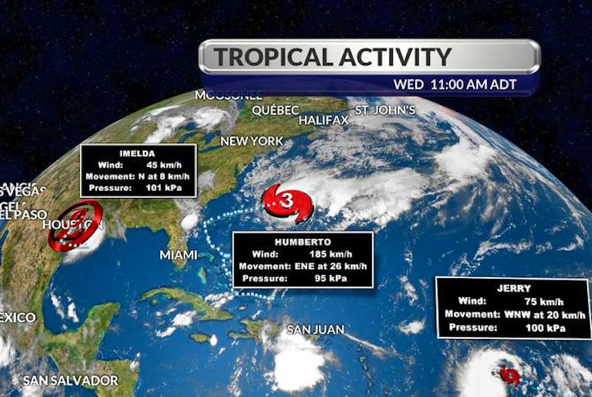
The three named storms are Imelda, Humberto and now Jerry, which was just upgraded to a tropical storm and earned its name Wednesday.
Imelda was a hurricane in the Gulf of Mexico but is now just a rainstorm dropping heavy precipitation along Mexico’s east coast, Day said.
Humberto packs the biggest punch.
“Hurricane Humberto is now a category three,” she said, adding that the tempest was upgraded on Wednesday with winds reaching more than 178 kilometres per hour.
That’s “a major hurricane,” she said. It was expected to track across Bermuda on Wednesday night.
“That’s the one that’s going to come closest to us, if you will. There’s no landfall expected with Humberto. The closest brush it might make would be south of the Avalon, just under 400 kilometres south of the Avalon Saturday night. So there’ll be some showers on the Avalon, maybe gusts to 60 (km/h) but that’s it, no landfall.”
When asked what the deal was with Jerry, she said it’s expected to stay as a category one storm, defined as winds between 119 and 153 km/h and hopefully track east of the Bahamas.
“So it looks like, unless things change, it will stay over wide open water and stay away from coastal areas of the Bahamas,” Day said.
“Imelda (is) definitely not a concern. Jerry, probably not, either, but we will keep an eye on that one. And we know now that because of the blocking ridge that’s set up, this cold air, we thank the cold temperatures, the clear, cold air, for creating a bit of a wall and keeping Humberto off our coastline. If not for that ridge, it would come straight for Halifax. So this is good that it set up that way.”
She said residents in our region should expect to see a little bit of high, wispy cloud Friday off the back of the system.
The prevailing winds will be a bit in flux, with the return of south winds on Thursday and Friday warming things up. Then there will be a shift to a north wind off that followed by another shift to winds from the south on Sunday.
Day said the systems are typical for hurricane season.
“Third and fourth weeks of September are always the busiest couple of weeks in hurricane season,” she said. “And especially for our waters, because we hit our peak at the end of September, so we’ve got the warmest water, so if anything is going to track this way, it has some hope of staying as a very significant storm. ... It’s peak hurricane season, so we’ll watch these closely.”
Hurricane classifications measured by wind speed (km/h)
- Category 1: 119-153
- Category 2: 154-177
- Category 3: 178-208
- Category 4: 209-251
- Category 5: sustained winds over 252 km/h