Many of today’s sci-fi and disaster films include plots where hurricanes merge into one super-storm. Is that possible? What would happen if two or more storms actually did collide?

Well, it does happen and it doesn’t trigger Armageddon. When it happens, meteorologists refer to it as the Fujiwhara Effect. Dr. Sakarei Fujiwhara was a Japanese meteorologist who first observed the behavior, which is described as the orbiting of two or more weather systems that are in close proximity.
Regular low-pressure systems typically interact when they’re about 2,000 km apart. Tropical cyclones and hurricanes can begin to interact when the distance between them is less than 1,500 km. Then what happens? Do they merge into one big super-storm? In a case like this one, the storms “dance” around the common mid-point between them. Sometimes this is as far as the interaction goes. If one system is much larger than the other, the weaker of the cyclones will eventually spiral in towards that pivot point and the two will merge into a single storm.
The Fujiwhara effect tends to involve systems that rotate, but cyclones don't only interact with other cyclones.
Do you remember “The Perfect Storm?” It was one of weather history’s most famous examples of weather features coming together. They did so in 1991 along the East Coast of North America. In fact, three systems came together. A cold front that pushed off the Eastern seaboard interacted with a large low just east of Nova Scotia and, a few days late,r with Hurricane Grace.
When late-fall hurricanes merge with fronts, they often become powerful nor’easters. Who can forget Hurricane Sandy, also known as “Superstorm Sandy”, in 2012. The deadly hurricane first merged with an arctic front pushing south across Kentucky that resulted in 30 cm of snow over parts of West Virginia. On Oct. 29, Sandy merged with a second front and made landfall along the New Jersey coast with winds of 130 km/h. During the next four days, Sandy’s remnants drifted northward over Ontario and then eastward before merging with another low-pressure area over our region on Nov. 2.
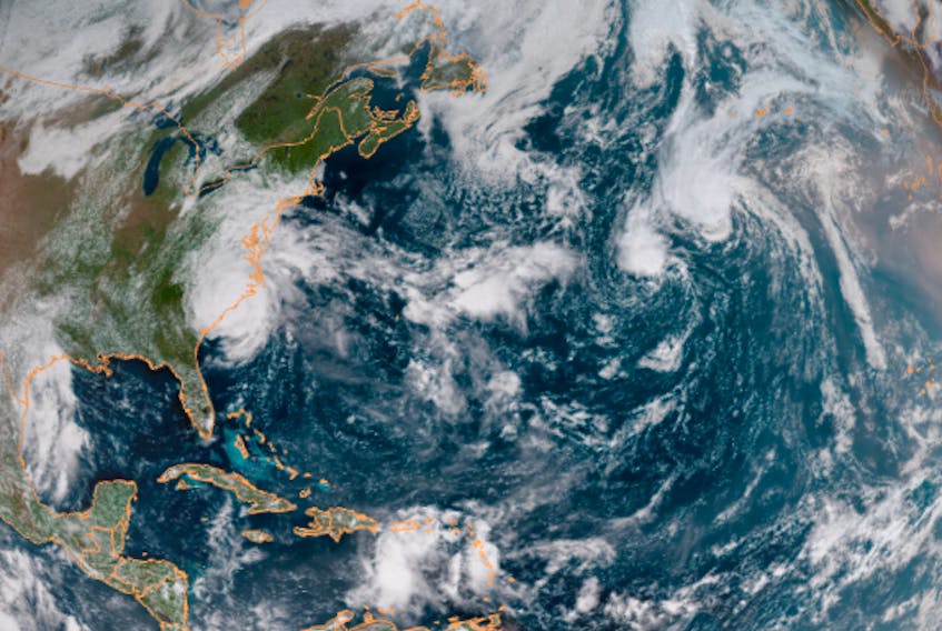
If you’re looking for a current example of the Fujiwhara Effect, Helene and Joyce, two tropical storms out over the mid-Atlantic, are doing that dance right now.
- Want more weather information? Visit WeatherByDay.ca
- Have a weather question, photo or drawing to share with Cindy Day? Email [email protected]
Cindy Day is the chief meteorologist for SaltWire Network.