That midweek spring storm was quite something, regardless of where you live in Atlantic Canada. Rainfall totals were as high as 70 mm in Shelburne, N.S., and Doaktown, N.B., took top honours in the snow department with 28 cm of new snow.
The wind was wild from northern New Brunswick to eastern Labrador, but some of the strongest winds were clocked in western Cape Breton, with a gust to 156 km/h in St. Joseph du Moine.
I started to track the developing energy last Friday. By Monday, I was referring to it as a powerful spring storm and then, after analyzing the expected drop in central pressure, I started calling it what it would be – a weather bomb. Well, it didn't take very long for the social media floodgates to open – I was called an alarmist and accused of fear mongering.
Let me assure you that I don't believe in crying wolf. I’m very careful when it comes to describing approaching storms of any kind and chose appropriated terminology.
Weather bomb is a meteorological term used to explain rapid cyclogenesis, the development and strengthening of cyclonic circulation in the atmosphere.
The term “weather bomb” is correctly used when the central pressure of a developing storm drops at least 24 mb in 24 hours. This rapid drop in pressure is more likely to occur during a shoulder season – spring or fall – when warm and cold air masses collide.
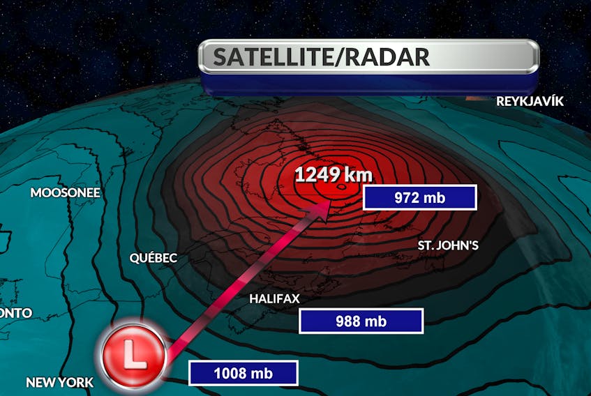
For the record, the central pressure of the low off Cape Cod Wednesday morning was 1,008 mb; by Thursday morning, the storm’s central pressure was 972 mb – a drop of 36 mb in 24 hours.
As the storm approached, I heard the term “Nor’easter” used to describe the powerful system. By definition, a Nor’easter is a storm that tracks up along the east coast of North America. It’s named for the direction of the wind wrapping around the storm and not for the direction of movement of the storm itself. The midweek wallop served up strong winds alright, but they were blowing from the east, then they backed to the southeast, eventually to the southwest and west.
It was a weather bomb and we’re glad it’s gone.
- Read more Weather University columns.
- Have a weather question, photo or drawing to share with Cindy Day? Email [email protected]
Cindy Day is the chief meteorologist for SaltWire Network.
RELATED